
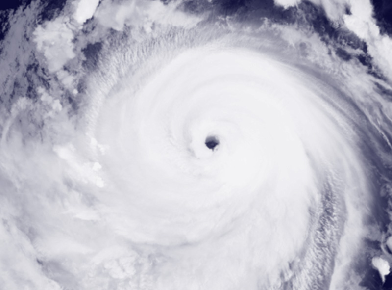
Darilaut – Typhoon Bavi makes landfall on the Yuhuan coast of East China’s Zhejiang Province at midnight on Saturday (July 11).
Bavi weakened from a severe typhoon to a typhoon yesterday and made landfall in Yuhuan, Zhejiang, that evening, according to the Hong Kong Observatory (HKO).
As of 11:00 p.m. Saturday, Bavi was centered about 60 kilometers east of Wenzhou.
After landfall, the system moved northwestward at about 30 kilometers per hour across Zhejiang.
As of 5:00 a.m. Sunday local time, Bavi was centered about 120 kilometers south of Hangzhou, according to the HKO.
The system is expected to move northwestward at about 22 kilometers per hour across eastern China and gradually weaken.
Before landfall, the Japan Meteorological Agency (JMA) said the system was packing maximum sustained winds around the center of 35 meters per second (70 knots) and maximum instantaneous sustained winds of 50 meters per second (100 knots).
The storm had sustained winds of 50 knots or more to the east 440 km (240 NM) and to the west 165 km (90 NM).
Strong winds of 30 knots or more to the southeast 750 km (400 NM) and northwest 650 km (350 NM), the JMA said.
Bavi, a strong typhoon, was moving northwestward at 25 km per hour (14 knots).
The barometric pressure at its center was 955 hPa (hectopascals), according to the JMA.

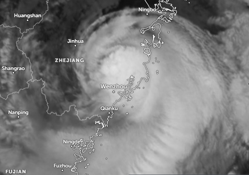
For the past six hours, according to the Joint Typhoon Warning Center (JTWC), Bavi had been moving northwestward at 30 km per hour (16 knots). The maximum significant wave height is 15.8 meters (52 feet).
Rapid weakening will occur as the system crosses land near the Yangtze River Delta, until dissipation occurs in two days.
Due to the wide wind field, a large swath of strong winds will persist offshore China, pushing northward toward the Yellow Sea, the JTWC said.
An alternative scenario would be for a low-level circulation to persist over land and emerge in the Yellow Sea after two days.
If this occurs, the system would acquire baroclinic characteristics as it interacts with the jet stream to the north, undergoing an extratropical transition as it crosses the Yellow Sea and the Korean Peninsula, according to the JTWC.
According to Xinhua, Typhoon Bavi had maximum sustained winds at its center of 40 meters per second upon landfall. Bavi first made landfall in Yuhuan City, a county-level city administered by Taizhou City, and then in Yueqing City, a county-level city under Wenzhou City, around midnight.
After landfall, the typhoon is expected to continue moving northwestward while weakening.
The typhoon is expected to bring heavy rain to coastal areas of Zhejiang and its central and southern regions overnight, and heavy to very heavy rain to its western regions on Sunday (July 12).
Hits Okinawa
While crossing southern Japan, Typhoon Bavi made landfall in Okinawa on Saturday (July 11).
The typhoon is gradually moving away from Okinawa Prefecture, but strong winds are expected to continue. Authorities are also urging vigilance for high waves.
The Japan Meteorological Agency said Typhoon Bavi was in waters north of Yonaguni Island as of 5:00 p.m. Saturday.
According to NHK, officials said the storm was moving northwest at 30 kilometers per hour.
The region is also being hit by heavy rain. The Sakishima Islands could receive up to 150 millimeters of rain by Sunday afternoon (July 12).
High seas are expected in the Okinawa and Amami regions. Authorities are urging vigilance for high waves and strong winds.
Wind gusts in Hirara on Miyakojima Island reached around 154 kilometers per hour shortly after 10:00 a.m.
More than 250 flights have been canceled, including flights to and from Okinawa’s Naha Airport, Kagoshima Airport, and airports on outlying islands in Kagoshima Prefecture.
Airlines said more flights could be canceled or delayed depending on the situation.
17 Dead in the Philippines
Typhoon Bavi has claimed 17 lives in the Philippines. Typhoon Bavi, known as “Inday,” brought rains that reached over 1,200 kilometers (720 miles) across Sarangani, which was recently struck by a 7.8-magnitude earthquake.
Seventeen people were reported dead, while approximately 514,700 were affected by the southwest monsoon (habagat) strengthened by Typhoon Inday, the National Disaster Risk Reduction and Management Council (NDRRMC) said on Saturday (July 11).
According to the Philippine News Agency (PNA), the deaths were caused by drowning and landslides, with two recorded in Bukidnon; 10 in Malapatan, Sarangani; and five in Calanogas, Lanao Del Sur.
Four people were also reported injured by landslides in Torrijos, Marinduque; Malapatan; and Calanogas.
Nine people were reported missing—three from Malapatan and six from Calanogas.
At least 14,000 families have been displaced, with 2,900 of them in evacuation centers.
87 Injured in Taiwan
Focustaiwan.tw reported that Typhoon Bavi, which struck Taiwan on Saturday (July 11), injured 87 people, prompted the evacuation of 14,476 residents nationwide, and cut off power to 177,485 households.
As of 3:00 p.m. Saturday, there were 1,456 reports of fallen trees and infrastructure damage caused by the typhoon, mostly in New Taipei and Taichung, and 614 reports were pending.
Super Typhoon Bavi
Typhoon Bavi has been on a long journey since forming as a tropical storm near the Micronesian Islands in the western Pacific Ocean on Thursday (July 2). Bavi then strengthened into a typhoon and then a super typhoon as it crossed the Northern Mariana Islands.
Bavi has been moving northwest at 24 km per hour (13 knots) for the past six hours. The maximum significant wave height was 7 meters (23 feet), according to the JTWC.
Super Typhoon Bavi was moving in the western Pacific Ocean toward the Northern Mariana Islands on Saturday (July 4).
Bavi formed a new eyewall 634 km east-southeast of the Northern Mariana Islands or 684 km east of Guam.
The maximum significant wave height was 13.4 meters (44 feet), according to the JTWC.
Super Typhoon Bavi then passed over the Northern Mariana Islands on Monday morning (July 6).
As it crossed the Northern Mariana Islands, Bavi formed a new eyewall (core). The system made landfall on or near the island of Rota.
Super Typhoon Bavi was located 65 km west-northwest of Rota on Monday afternoon, or 100 km north of Guam.
After hitting the Northern Mariana Islands, Bavi was already in the Philippine Sea, moving northwest at 20 km/h (11 knots). The maximum significant wave height was 16.5 meters (54 feet).
The system is heading east of Taiwan, southern Japan, and the east coast of China.