
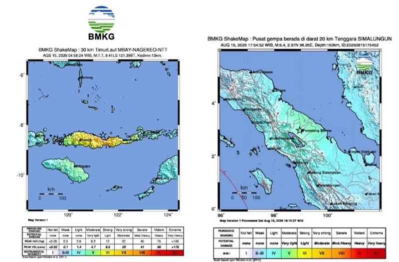
Darilaut – In the span of just one day, very strong earthquakes shook Indonesia, striking locations in the east and west. These powerful quakes occurred at sea and on land, separated by a distance of approximately 3,000 km (1,900 miles).
The first earthquake, an offshore event with a magnitude (M) of 7.7, struck near Flores, East Nusa Tenggara (NTT), on Saturday (August 15) at 04:58:24 WIB (Western Indonesian Time) or 05:58:24 WITA (Central Indonesian Time).
Subsequently, a second earthquake—with a magnitude (M) of 6.4—occurred on land in North Sumatra Province on Saturday afternoon. This quake struck at 17:54 WIB.
The NTT earthquake triggered a tsunami that was observed at ten coastal locations. Tide gauge networks recorded tsunami waves arriving in Reo (Manggarai) and East Manggarai with peak heights reaching 1.61 meters; in Maurole (Ende) at 0.94 meters; and in Bulukumba and Sape (Bima) at levels exceeding 0.5 meters. The Meteorology, Climatology, and Geophysics Agency (BMKG) lifted all tsunami early warnings at 07:30 WIB.
BMKG Head Teuku Faisal Fathani explained that these events are classified as shallow earthquakes resulting from activity along the Flores Back Arc Thrust fault. Historically, the Flores Back Arc Thrust structure holds a long record of destructive earthquakes, including a magnitude 7.8 (M7.8) quake at a depth of 28 km that struck the region in 1992.
In contrast, this earthquake originated at a much shallower depth (15 km), causing relatively severe physical damage to infrastructure and triggering a tsunami observed as far as the coasts of South and Southeast Sulawesi.
Aftershock activity has been distributed north of Flores Island, with magnitudes ranging from M 2.5 to M 6.2. Monitoring data indicates that the trend of recorded aftershocks has not yet shown a significant decline.
Based on the shake intensity map, the BMKG recorded peak shaking reaching MMI scale VII in the Aesesa area (Nagekeo Regency), Riung (Ngada Regency), and Ambai City, as well as through direct micro-observations in the Manggarai and Ruteng areas. MMI scale VI was recorded in Wolowae (Nagekeo) and Bajawa City, while MMI scale V was felt in several surrounding areas.
The United States Geological Survey (USGS) reported that the Flores Sea earthquake—with a magnitude of M 7.7—occurred on Saturday morning (August 15) off the northern coast of NTT, caused by a shallow-depth thrust fault.
This powerful earthquake struck a seismically active region dominated by the convergence of the Australian and Sunda plates.
By Saturday afternoon, more than 250 aftershocks had occurred.
The National Disaster Management Agency (BNPB) recorded dozens of fatalities across several areas of NTT, along with damage to at least 90 buildings.
A second earthquake, with a magnitude of M 6.4, occurred onshore in North Sumatra on Saturday afternoon (August 15). The earthquake was strongly felt for 30 seconds in Simalungun Regency, Medan City, and Pakpak Regency. Meanwhile, in Central Tapanuli Regency, the quake was strongly felt for 10 seconds.
According to the BMKG, the earthquake’s epicenter was located at 2.97° N latitude and 98.95° E longitude, at a depth of 163 kilometers. The quake originated inland and posed no tsunami threat.
The North Sumatra Provincial Regional Disaster Management Agency (BPBD) reported that the earthquake was felt in several areas, including Simalungun Regency, Medan City, Pakpak Bharat Regency, and Central Tapanuli Regency.
The United States Geological Survey (USGS) recorded a magnitude 6.9 earthquake located 15 km north-northwest of Pematangsiantar. The earthquake occurred at a depth of 172.5 km.
Automated USGS analysis identified the nearest locations as Pematangsiantar (15.3 km / 9.5 miles), Pekan Bahapal – Simalungun (17.9 km / 11.1 miles), Tebing Tinggi (31.6 km / 19.6 miles), Parapat – Simalungun (47.9 km / 29.8 miles), and Medan (67.6 km / 42 miles).