
Darilaut – A tectonic earthquake with a magnitude (M) of 7.7 shook the Flores region, East Nusa Tenggara (NTT), on Saturday morning (August 15) at 04:58 WIB (Western Indonesian Time). The massive earthquake was followed by tsunami waves that reached 10 coastal locations.
The Meteorology, Climatology, and Geophysics Agency (BMKG) identified this shallow earthquake—occurring at a depth of 15 km—as originating from the activity of the Flores Back-Arc Thrust. Following the main shock, the BMKG recorded 235 aftershocks up to 14:00 WIB on Saturday.
BMKG Head Teuku Faisal Fathani explained that this event is classified as a shallow earthquake resulting from activity along the Flores Back-Arc Thrust fault.
Historically, the Flores Back-Arc Thrust structure has a long record of destructive earthquakes, including an M7.8 quake at a depth of 28 km that struck the region in 1992.
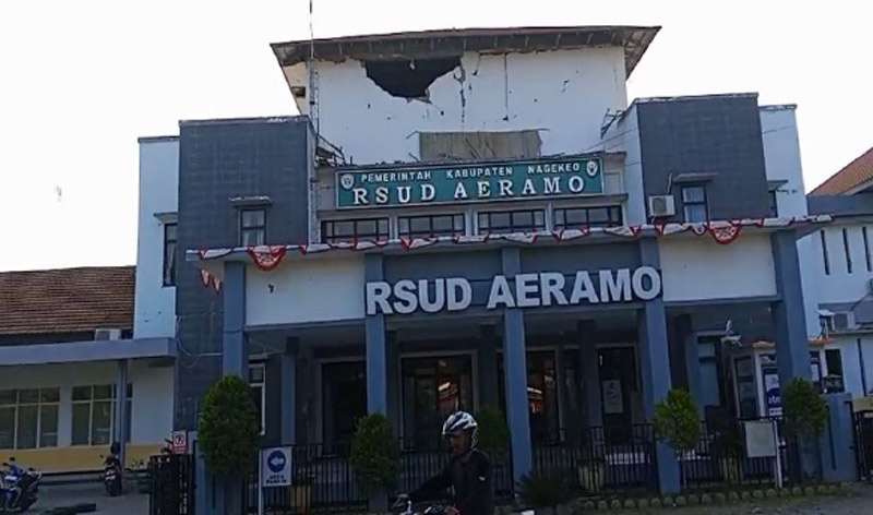
However, this earthquake was centered at a much shallower depth (15 km), causing relatively severe physical damage to infrastructure and triggering a tsunami observed as far as the coasts of South Sulawesi and Southeast Sulawesi.
The aftershocks were distributed north of Flores Island, with magnitudes ranging from M2.5 to M6.2. Monitoring data indicates that the trend of aftershock activity has not yet shown a significant decline.
The BMKG also noted that the movement of the thrust fault caused strong shaking and carried the potential to generate a tsunami. Tsunami
Earlier, the BMKG confirmed an update to the data for the shallow tectonic earthquake, revising the magnitude to M7.7 with a depth of 15 km. The BMKG’s earthquake monitoring system responded rapidly to the event, issuing a tsunami early warning just 2 minutes and 16 seconds after the main shock. Monitoring staff subsequently updated the tsunami early warning 10 minutes later, once the earthquake parameters had stabilized and become precise.
The earthquake triggered tsunami waves that struck several coastal areas. The BMKG utilized a multi-scenario modeling system and classified threat levels into ‘Alert’ (potential wave heights of 0.5 to 3 meters) and ‘Advisory’ (heights below 0.5 meters).
The sea-level observation network (tide gauges) recorded tsunami waves arriving in Reo (Manggarai) and East Manggarai with peak heights reaching 1.61 meters; in Maurole (Ende) at 0.94 meters; and in Bulukumba and Sape (Bima), where heights exceeded 0.5 meters.
BMKG monitoring stations recorded tsunami waves arriving at ten coastal locations. These included: Sikka, with a height of 0.20 meters (at 05:03 WIB); Kewapante Port, Sikka, at 0.38 meters (at 05:16 WIB); East Flores at 0.25 meters (at 05:24 WIB); and Labuan Bajo at 0.36 meters (at 05:26 WIB).
Additionally, waves were recorded in Maurole, Ende, at 0.94 meters (at 05:27 WIB); Dompu at 0.17 meters (at 05:29 WIB); and Bakalang, Alor, at 0.14 meters (at 05:41 WIB). Baubau recorded a height of 0.30 meters (at 05:47 WIB); Bulukumba, 0.54 meters (at 05:58 WIB); and Kolaka, 0.23 meters (at 06:27 WIB). The BMKG lifted the tsunami early warning at 07:30 WIB.
“The BMKG is no longer recording any significant rise in sea levels that would endanger communities along the affected coastlines,” said BMKG Deputy for Geophysics, Nelly Florida Riama, in Jakarta on Saturday (August 15).
“The tsunami early warning has been declared over, though aftershocks are continuing. We urge the public to remain calm, not to be swayed by irresponsible rumors, and to stay updated via official BMKG channels.”
The BMKG officially lifted all tsunami early warnings at 07:30 WIB after sea-level monitoring confirmed that conditions had returned to a safe state.
Based on the shaking intensity map, the BMKG recorded peak shaking reaching the MMI VII scale in the areas of Aesesa (Nagekeo Regency), Riung (Ngada Regency), and Ambai City, as well as through direct micro-observation in the Manggarai and Ruteng regions. Shaking at the MMI VI scale was measured in Wolowae (Nagekeo) and Bajawa City, while MMI V shaking was felt in several surrounding areas.
Preliminary data from the East Nusa Tenggara (NTT) Regional Disaster Management Agency (BPBD) indicates that dozens of people have died or sustained injuries. Fatalities occurred in Sikka, West Manggarai, Manggarai, and East Manggarai Regencies.
Residential buildings and public facilities sustained damage ranging from severe to moderate and minor. Affected public facilities include the Laurens Say Maumere Port Office, the Ende-Maumere road (Km 17), the Ende-Aegela road, the Waelengga-Mborong road, the Unika Ruteng campus, and the BRI Mborong office; additionally, sections of the Trans Ende-Nagekeo road and the Ende-Arubara road were blocked by cliff collapses.