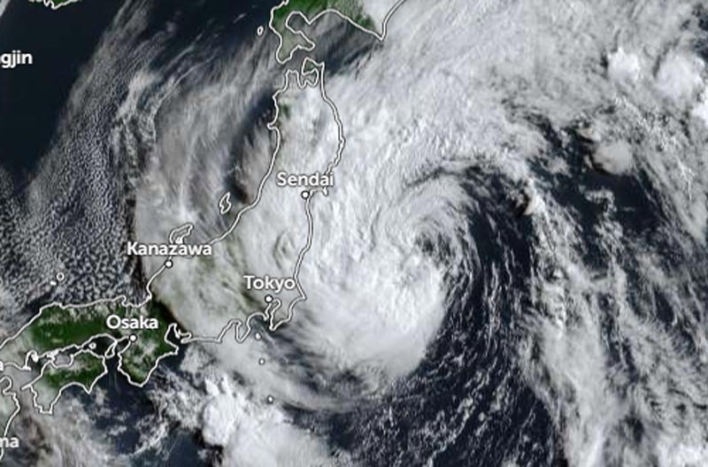
Darilaut – Tropical Storm Chan-hom is currently located near Tokyo, Japan, in the southwestern Pacific Ocean as of Tuesday (Aug 11) morning.
Chan-hom is situated 466 km east-northeast of Tokyo or 356 km east-southeast of Sendai. The storm is expected to make landfall on Honshu Island today.
The Japan Meteorological Agency (JMA) reported that as of 06:00 local time on Tuesday, Chan-hom was moving west-northwest at a speed of 35 km/h (18 knots).
The system has a central atmospheric pressure of 985 hPa (hectopascals).
Chan-hom—Japan’s 15th typhoon of the season—packs maximum sustained winds of 23 meters per second (45 knots) near its center, with peak instantaneous wind speeds reaching 35 meters per second (65 knots).
An area of strong winds (30 knots or greater) extends 500 km (270 nautical miles) to the east and 390 km (210 nautical miles) to the west of the center, according to the JMA.
Over the past six hours, Chan-hom has moved northwest at 35 km/h (19 knots). Maximum significant wave heights have reached 7.6 meters (25 feet), according to the Joint Typhoon Warning Center (JTWC).
According to the JTWC, Chan-hom is entering the final stage of its approach to the Japanese mainland. The storm has begun to accelerate and turn westward, curving around a strong deep upper-level low-pressure system located to its south.