
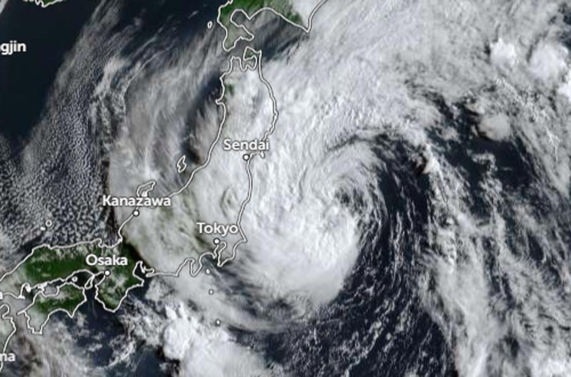
Darilaut – Tropical Storm Chan-hom is currently located near Tokyo, Japan, in the southwestern Pacific Ocean as of Tuesday (Aug 11) morning.
Chan-hom is situated 466 km east-northeast of Tokyo or 356 km east-southeast of Sendai. The storm is expected to make landfall on Honshu Island today.
The Japan Meteorological Agency (JMA) reported that as of 06:00 local time on Tuesday, Chan-hom was moving west-northwest at a speed of 35 km/h (18 knots).
The system has a central atmospheric pressure of 985 hPa (hectopascals).
Chan-hom—Japan’s 15th typhoon of the season—packs maximum sustained winds of 23 meters per second (45 knots) near its center, with peak instantaneous wind speeds reaching 35 meters per second (65 knots).
An area of strong winds (30 knots or greater) extends 500 km (270 nautical miles) to the east and 390 km (210 nautical miles) to the west of the center, according to the JMA.
Over the past six hours, Chan-hom has moved northwest at 35 km/h (19 knots). Maximum significant wave heights have reached 7.6 meters (25 feet), according to the Joint Typhoon Warning Center (JTWC).
According to the JTWC, Chan-hom is entering the final stage of its approach to the Japanese mainland. The storm has begun to accelerate and turn westward, curving around a strong deep upper-level low-pressure system located to its south.
Intensity forecasts are heavily influenced by the presence of oceanic eddies and Chan-hom’s interaction with the deep upper-level low-pressure system to the south. According to the JTWC, the storm crossed a cold-core eddy on Monday (August 10), which contributed to a short-term decline in deep convection activity.
The storm is set to cross a much warmer eddy associated with the Kuroshio Current, where sea surface temperatures reach 27–28°C. These conditions have the potential to reinvigorate deep convection.
However, increased wind shear and the entrainment of dry air—driven by a nearby low-pressure center—will likely limit or even prevent the storm from intensifying.
Storm Peilou
Meanwhile, Tropical Storm Peilou is moving northeast toward the North Pacific. Peilou—Japan’s 16th typhoon of the season—has a central pressure of 992 hPa.
The JMA reports maximum sustained winds of 23 meters per second (45 knots) near the center, with peak instantaneous gusts reaching 35 meters per second (65 knots).
The JMA notes that the area of strong winds (30 knots or greater) extends 390 km (210 NM) to the southeast and 220 km (120 NM) to the northwest.
The JTWC reports a maximum significant wave height of 4.6 meters (15 feet).
The JTWC forecasts that Peilou will continue its northeastward track, embedded within the southwest monsoon flow on the eastern periphery of a broad cyclonic circulation located to the west.
The system is expected to dissipate over open water within the next two days.