
Sabtu, Agustus 8, 2026
Beri Dukungan
redaksi@darilaut.id
Dari Laut
Tidak ada hasil
Lihat Semua Hasil
  • Masuk
  • Daftar
  • Home
  • Berita
    • Laporan Khusus
    • Bisnis dan Investasi
    • Pemilu & Pilkada
    • Kesehatan
  • Eksplorasi
  • Kajian
  • Sampah & Polusi
  • Tips & Trip
    • Ide & Inovasi
    • Travel
  • Konservasi
    • Orca
    • Hiu Paus
    • Biota Eksotis
  • Cek Fakta
  • Iklim
  • Advertorial
  • Home
  • Berita
    • Laporan Khusus
    • Bisnis dan Investasi
    • Pemilu & Pilkada
    • Kesehatan
  • Eksplorasi
  • Kajian
  • Sampah & Polusi
  • Tips & Trip
    • Ide & Inovasi
    • Travel
  • Konservasi
    • Orca
    • Hiu Paus
    • Biota Eksotis
  • Cek Fakta
  • Iklim
  • Advertorial
Tidak ada hasil
Lihat Semua Hasil
Dari Laut
Tidak ada hasil
Lihat Semua Hasil
Home Berita

Typhoon Dolphin’s Path Forms a Hexagonal Pattern Heading Toward China’s East Coast

redaksi
8 Agustus 2026
Kategori : Berita
0
Typhoon Dolphin’s Path Forms a Hexagonal Pattern Heading Toward China’s East Coast

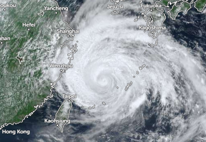
Typhoon Dolphin in the East China Sea on Saturday (Aug. 8) afternoon. IMAGE: ZOOM.EARTH

As of 11:00 a.m. local time on Saturday, Dolphin was heading west-northwest at a speed of 15 km/h (9 knots).

The system has a central pressure of 945 hPa (hectopascals), packing maximum sustained winds of 45 meters per second (85 knots) near its center and peak instantaneous wind speeds of 60 meters per second (120 knots), according to the JMA. The JMA reported a storm-force wind area (speeds of 50 knots or higher) extending 280 km (150 NM) to the north and 185 km (100 NM) to the south of the center.
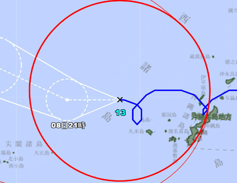
The path of Typhoon Dolphin, forming four corners and a hexagonal pattern. IMAGE: JMA

A gale-force wind area (speeds of 30 knots or higher) extends 560 km (300 NM) to the north and 500 km (270 NM) to the south.

As of 11:30 a.m. Saturday, based on the Zoom.earth tracking path, Typhoon Dolphin was located 500 km east-southeast of Wenzhou.

Earlier, at 10:00 a.m., the center of Dolphin was approximately 520 kilometers east-southeast of Wenzhou, according to the Hong Kong Observatory (HKO).

The HKO forecasts that Dolphin will move westward at about 10 kilometers per hour across the East China Sea. As Tropical Cyclone Dolphin moves toward the Zhejiang and northern Fujian regions, subsiding air from the storm’s outer circulation will continue to cause very hot weather in the area throughout the weekend and into Monday.

High temperatures will also trigger thunderstorms. Southwesterly airflow is expected to affect coastal Guangdong by the middle of next week.

Halaman 2 dari 3
Sebelumnya123Selanjutnya
Tags: East China SeaHKOJMAJTWCTyphoon Dolphin
BagikanTweetKirimKirim
Previous Post

Unik, Lintasan Topan Dolphin Membentuk Pola Segi Enam Menuju Pantai Timur Cina

Postingan Terkait

Unik, Lintasan Topan Dolphin Membentuk Pola Segi Enam Menuju Pantai Timur Cina

Unik, Lintasan Topan Dolphin Membentuk Pola Segi Enam Menuju Pantai Timur Cina

8 Agustus 2026
74 Mahasiswa Profesi Ners UNG Awali Langkah Menjadi Perawat Profesional

74 Mahasiswa Profesi Ners UNG Awali Langkah Menjadi Perawat Profesional

8 Agustus 2026

Topan Dolphin Berada Sangat Dekat dengan Pulau Okinawa Jepang

Dampak Kekeringan, Lebih Dari 15 Ribu Warga di Provinsi Gorontalo Sulit Air Bersih

Typhoon Dolphin Struck Japan’s Amami and Okinawa Islands

Topan Dolphin Menghantam Amami dan Okinawa Jepang, Bawa Angin Kencang dan Gelombang Tinggi

Alfred Russel Wallace Menganjurkan Penelitian Laut Dalam Indonesia

Topan Dolphin Akan Menerjang Okinawa dan Amami

TERBARU

Typhoon Dolphin’s Path Forms a Hexagonal Pattern Heading Toward China’s East Coast

Unik, Lintasan Topan Dolphin Membentuk Pola Segi Enam Menuju Pantai Timur Cina

74 Mahasiswa Profesi Ners UNG Awali Langkah Menjadi Perawat Profesional

Topan Dolphin Berada Sangat Dekat dengan Pulau Okinawa Jepang

Dampak Kekeringan, Lebih Dari 15 Ribu Warga di Provinsi Gorontalo Sulit Air Bersih

Typhoon Dolphin Struck Japan’s Amami and Okinawa Islands

AmsiNews

REKOMENDASI

Menteri Suharso Jelaskan Smart City dan Transformasi Digital

La Nina Masih Berlanjut, WMO: Maret-April-Mei 2026 Curah Hujan di Pasifik Khatulistiwa Tetap Konsisten

Edudive Center UNG Selaras dengan Program Kampus Berdampak Kemdiktisaintek

Badai Tropis Wipha Terbentuk di Dekat Filipina

BTKP Uji Alat Keselamatan di KM Santika Nusantara yang Terbakar di Masalembo

Bibit Siklon Tropis 97S Menjauh Dari Indonesia

Kategori

  • Advertorial
  • Berita
  • Biota Eksotis
  • Bisnis dan Investasi
  • Cek Fakta
  • Eksplorasi
  • Hiu Paus
  • Ide & Inovasi
  • Iklim
  • Kajian
  • Kesehatan
  • Konservasi
  • Laporan Khusus
  • Orca
  • Pemilu & Pilkada
  • Sampah & Polusi
  • Tips & Trip
  • Travel
  • Video

About

  • Tentang
  • Redaksi
  • Disclaimer
  • Terms of Use
  • Kebijakan Privasi
  • Pedoman Pemberitaan Media Siber
  • Trustworthy News Indicators
Dari Laut

darilaut.id

Menginformasikan berbagai perihal tentang laut, pesisir, ikan, kapal, berita terkini dan lain sebagainya.

redaksi@darilaut.id
+62 851 5636 1747

© 2026 DARILAUT - Berita terbaru dan terkini hari ini - darilaut.id.

Selamat Datang Kembali

Masuk dengan Facebook
Masuk dengan Google+
Atau

Masuk Akun

Lupa Password? Mendaftar

Buat Akun Baru

Mendaftar dengan Facebook
Mendaftar dengan Google+
Atau

Isi formulir di bawah ini untuk mendaftar

Isi semua yang diperlukan Masuk

Ambil password

Masukan username atau email untuk mereset password

Masuk
Tidak ada hasil
Lihat Semua Hasil
  • Home
  • Berita
  • Pemilu & Pilkada
  • Laporan Khusus
  • Eksplorasi
  • Sampah & Polusi
  • Tips & Trip
  • Biota Eksotis
  • Cek Fakta
  • Ide & Inovasi
  • Konservasi
  • Kajian
  • Kesehatan
  • Orca
  • Hiu Paus
  • Bisnis dan Investasi
  • Travel
  • Iklim
  • Advertorial

© 2026 DARILAUT - Berita terbaru dan terkini hari ini - darilaut.id.

This website uses cookies. By continuing to use this website you are giving consent to cookies being used. Visit our Privacy and Cookie Policy.